The Fitchburg Line Industrial Corridor
Boston is a very post-industrial city. East Cambridge and Somerville especially were big industrial districts around the turn of the last century, but the industrial jobs drained away in the 50s, 60s and 70s, a little ahead of the national trend towards deindustrialization. Research, finance, and the ever-expanding giants of Harvard and MIT, as well as a host of lesser schools, are the base of Boston's economy these days. For years, I wondered if there were any factories left that hadn't been converted into office and lab space for IT companies and biotech startups. But then I moved to Somerville and found an agglomeration of industrial buildings that were still Making Stuff, most of them huddled up against a railway track running south of Somerville Ave. This track was part of the Fitchburg Railroad, which was leased by the B&M railroad, and then bought by the MBTA in the 1970s; now it's the Fitchburg Line of the MBTA's commuter rail service.
There are at least four large businesses that I know of occupying this little cluster of industry: Ames Safety Envelope, which occupies a dwindling share of a huge complex of buildings divided by Dane Street; the Peter Forg Manufacturing Co., which does metal stamping and fabricating right across the track from Ames; L. Bornstein Flooring, which operates a large and ugly structure north of Washington Street; and the H.D. Chasen Company, which sells industrial supplies out of a small complex on Lake Street. There's also a clutch of smaller industrial businesses or former businesses operating from smaller buildings. I've collected some information on the history of the locations on this page from the Sanborn maps available through the Somerville Public Library.
I had been meaning to photograph this area for some time, but ultimately it was an internet friend's comment that "you are near a METALWORKING plant and I haven't seen pictures?!?!" that spurred me to action. So, beginning on a beautiful day in May, I went on a series of expeditions to explore and document some of the last working factories in Somerville. (The lighting conditions weren't always great, so I've done a fair amount of quick and dirty enhancement in Photoshop to create the final images.)
To give an idea of the geography of the area, I've created a Google map showing the locations of the buildings I've photographed.
The Ames Complex
The Ames company has been in existence since 1919; it started off making envelopes (hence "Ames Safety Envelope Company", still the business' official name of the company), and branched out into packing materials, office supplies, on-demand printing, and probably some other stuff that I didn't notice from skimming their website. The company was started by a John Fitzgerald, so I'm guessing that either someone named Ames bought the shop somewhere along the line, or perhaps "Fitzgerald" wasn't a name you wanted attached to a business back then. Over the decades, the Ames company amassed a large (by Boston standards) package of industrial buildings along the north side of the commuter rail tracks. To the east of Dane Street, they built over or took residence of a number of buildings that had once been the American Tube Works, one of the earliest heavy industrial plants in Somerville, a maker of brass tubing for steam heat systems. In the last few years, though, they've either shut down or moved some of their production facilities, and most of their Somerville facility has been rented out for other uses, or is standing empty.1. Looking south on Park Street at the western wing of the Ames complex. Until very recently -- a few months ago, I think -- the Ames company used this part of the complex as a factory; I used to walk by and look in the windows, and see people at a production line. I think they made file folders here. Since then, at least part of it has been rented out for other uses.

2. Further down the street. On the far right you can just see the railway crossing. There is still Stuff being Made in this very functional building. Just on a less industrial basis.

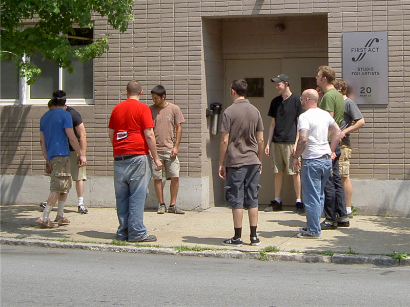
3. First Act Studios, the current resident of this part of the complex, makes musical instruments. Not just any old musical instruments either. They seem to focus on electric guitars and tube amps.

4. A quick snapshot through the window. I did a lot of enhancing here to brighten up the interior; it was quite dark compared to the sunny day outside.

Passing by on another day, I saw a group of First Act employees and/or their friends hanging out by the building, taking a break from their labors. Moments after I snapped this photo, they started playing hacky sack.
5.Same building, further along to the south. This part of the building still seems to be Ames property; the loading dock is in active use, with trucks moving in and out. Unfortunately the artifact in the center top is almost certainly some of my hair blowing around.

6. Just to the right of the loading dock, another building in the sprawling Ames complex. I'm pretty sure Ames is still using this one. You can see the other side of this building a little later on. The beautiful mural makes an interesting contrast with the Spartan quality of the building itself.

An interesting detail on the mural building.

Here's an enlargement of the sign on the door. I'm guessing that some part of the building was actually a substation operated by the local electric utility. This sign shows a fair bit of history. Are or were there really 624 other "vaults" in the Ames complex? Or just in Boston, or Somerville? Also, utility companies can't spell.

7.The mural itself. The lighting was rather bad on the first day, so this image is from a subsequent trip. I took this shot from the parking lot of a small printing company right across the street. There are a few such businesses nearby. Ames is apparently heavy into printing as well as manufacturing office supplies, so I wonder exactly what economic niche these outfits occupy, and what kind of competition is going on, or whether Ames farms out some of its printing work. Anyway, this here is your basic multi-ethnic civic pride mural. The hills in the background represent Somerville's seven hills. Apparently there's some disagreement on what the "seven hills of Somerville" are, because there are more than seven hills in Somerville.

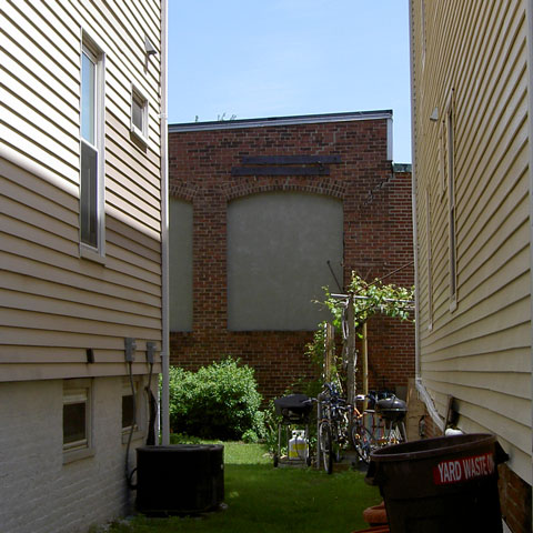
8. Continuing south, Park Street crosses the commuter rail tracks. This surface-level crossing is very convenient for taggers, as are the blank walls that face on the tracks. (Also very convenient for people who want to take pictures of their work.) On the left is the Ames mural building, and on the right, a corner of one of the Peter Forg buildings. Down the tracks is the Dane Street bridge.

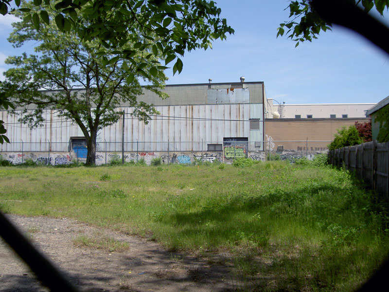
9. Looking north through a chain link fence in a small parking lot off Village Street. Across the tracks is the east end of the Ames mural building. The empty field belongs to the Forg company, whose buildings are out of frame to the left. I wonder what the loading docks facing on the tracks were for. This rail line has a long history, and definitely carried freight well into the 19th century.
10. The bridge on Dane Street, looking north. We've traveled east along Village Street and turned north onto Dane. On the far left, mostly obscured, is more of the same Ames complex seen earlier. The structures on the right are the former site of the American Tube Works, upon which was built the eastern part of the Ames complex. This bridge was originally made of wood and opened in the late 19th century.

Peggy took this great picture of the bridge's dedication.

11.The eastern Ames building, seen from the middle of the bridge. You can just see the parking lot on top of this structure, and, to the far left, the awning over a door, painted Ames' corporate red. However, as you'll see in a moment, Ames doesn't seem to own anything in this picture these days. In the distance on the right, the large brick building is part of H.D. Chasen.

12. Looking west at the other half of the Ames complex. The railroad company had a small plot of land on this site, approximately where the setback part of the building is now, possibly for coal sheds. Later, Middlesex Coal Co. used the same land to store coal, wood and hay. Park Street can be seen on the far left, where a car is passing.

13. Initially I had thought that all these buildings might have been built by Ames, but it seems that instead they all belonged to American Tube. The building in the foreground started life as a boiler house. When I moved to Somerville, it seemed to be owned by some kind of educational supply company. Now, along with all the Ames stuff east of Dane Street, it's in the hands of SecondWind, a company that makes sensors and electronics for wind farms. The building on the left was a drawing mill, one of four in this block, and then a garage for a milk distributor.

A beautiful doorway.

14. Looking east off Dane Street. This alley was once called Frost Avenue, but lost its identity at some point in the last century. Nonetheless, people walk or drive through here fairly often; I sometimes use it to get to the supermarket, whose side is the brick wall seen in the distance, past the blue semi truck. The large white-and-brick building on the right is the other side of the building in picture 11. Opposite that on the left, past the self-storage business, is another of American Tube's former drawing mills. Now it's home to an auto body shop and a judo club. Where the supermarket is now, American Tube had its shipping room, proving department, and yet another drawing mill.

15. Further down the alley. You can just barely see that the trailer to the right houses one of SecondWind's "sonic wind profilers". How beautiful and strange to live in a time when that process has serious industrial applications. More on these in a moment. American Tube had several smaller buildings where this building now stands, and after its departure, a number of businesses operated in them; see the Google map for more details.

TRITON!

16. Peggy at the door on the back side of 24 Dane Street. It took me a disgraceful amount of time to work out that "Dan Tree" was "Dane Street" with some letters taken out. I suspect a Mr. Dan Handman, aka dan-at-secondwind-dot-com, of peeling off the letters and drawing the corporate logo on the door.

17. Up on the parking lot. There was a guy smoking a cigarette out of frame to the left, who watched impassively as we walked up the ramp and wandered around taking photos. There were signs about video surveillance, but apparently nobody in Security Control could be bothered to notice or care sufficiently to chase us away.

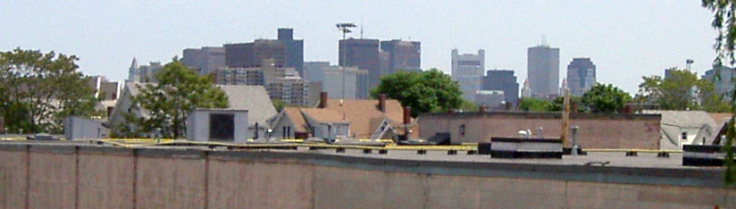
Frim the parking lot, looking south across the tracks. Cambridge and Somerville don't have many high-rises, so the office towers of Boston's financial district are readily visible. The white one with "horns" is the Federal Reserve. The dingy pink wall in the foreground is part of the L. Bornstein flooring company warehouse. More on that later.
18. Looking down from the parking lot. The gray things are indeed "TRITON Sonic Wind Profilers". These are apparently SODAR devices for tracking air flows. I love that they're solar powered. I wonder if they're left out in this little courtyard for weather testing.

I took another shot of one of the TRITON units from the alley, using zoom. These are very modern, information-age industrial products: smart, self-contained, stuffed with chips and advanced sensors, networked, shipping with their own software, and nestled in a sleek, consumer-product-y shell. They're "blogjects". They're practically "spimes". And they emerge from a factory that used to make color file folders.

20. Back on the alley that was Frost. This is the door to the more modern section of the building, with a few hints of internal structure past the reflections on the glass.

You can still see Ames signage and propaganda in the window. Ames seems like a pretty fun, free-wheeling kinda company to work for.

Looking along the north side of the alley.

You can just see the top of this door in the previous image. The building seems to house two or three auto-related businesses.

Further down the alley, looking north between the two former drawing mills.

At the end of the alley, looking west, back to where we came from. On the right is the Paper and Provisions Warehouse, built by American Tube to house a machine shop and smithy. Later it housed a metal fencing manufacturer and the paper manufacturer that gave it its name. Currently it houses the Somerville Boxing Club and an organ repair company. In the center left there's an Ames truck. I think they may still be moving equipment or goods out of this building.

Looking northwest at the Paper Warehouse, seen from the supermarket parking lot.

East side of the Paper Warehouse.

Looking south from Somerville Ave. To the right is part of Milk Row Cemetery.

Looking southwest across the Milk Row cemetery from Somerville Ave. On the left is the Paper Warehouse, in the center is one of the old drawing mills, and the building on the right is another American Tube structure.

Further west on Somerville Ave, looking south. This building originally held offices for American Tube, and then a small printing business. Now it's the Tree of Life tai chi center -- you can see the sign in the window on the upper right.

Continuing west on Somerville Ave, and looking backward.
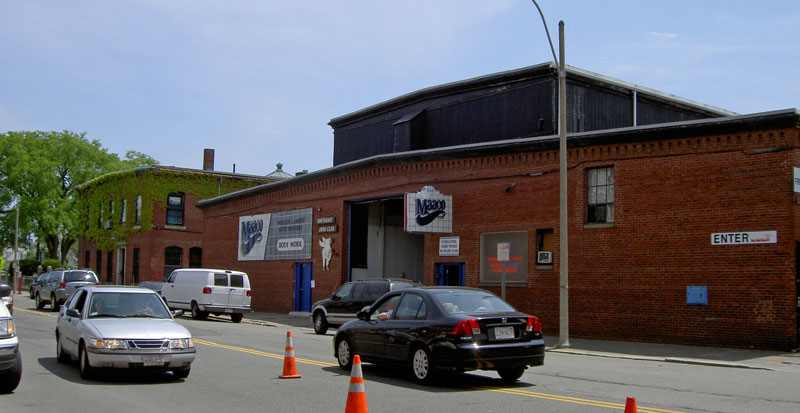
Down the alley between the Maaco and the tai chi center. The Ames building and the Paper Warehouse are visible at the end of the alley.

Further down the alley, panning 180 degrees from the previous image; looking north onto Somerville Ave.

Panning right from the previous image. I have no idea what the machinery stuck to the back of the building is. I'd like to speculate that it's some kind of leftover industrial equipment, but it looks a bit modern. It may just be part of the HVAC system. Also, someone loves that ancient Volvo.

The top of a doorway in the side of the tai chi center. Still looks very industrial in there.

Looking west down Tyler Street from Dane. From the previous image, we've walked west along the former Frost Ave and emerged onto Dane Street. This is the western part of the Ames complex; everything you can see belongs to them. I can't really tell if the blue lines are some kind of ultra-minimalist decoration or serve some unimaginable practical purpose.

On Tyler Street. Further down, the brutish industrial block turns into a slick, modern building. This is Ames' corporate headquarters .

23. The employee entrance (color-file division).

A quick snap through the glass. I can't tell if this is actually a factory or just a warehouse.

24. The sleek, modern, boring corporate headquarters entrance. Turning this corner, Tyler Street becomes Properzi Way. On current maps, Properzi seems to exist as two block-long little stubs of street interrupted by the Ames building and the tracks. Thus, there are actually two "Properzi Ways" in Somerville, nearly but not quite contiguous, and even more confusingly, the southern one was called Vine Street on earlier maps. This is part of why it's so difficult to navigate in Boston, although the intermittently helpful mass transit and non-Euclidean street layout don't help either.

Looking west. The wall at the end of the alley is the opposite side of the building in photos 3 to 5, and, of course, you can see the shiny skin of the headquarters to the left.

Looking south along Properzi, back towards the headquarters. The nearer building to the right is the opposite side of the one in photo 1. This seems to have been the first building that Ames occupied, and it was still their territory as of a few years ago, but now it's been rented out. It's hard to read the printing on the door, but the business on the right is Hemlock Ink, a subculture-friendly t-shirt and poster printing company. Hemlock Ink, First Act and SecondWind seem like archetypal examples of the more benign aspects of postmodern capitalism - sustainable energy, electric guitars, and t-shirts all within a three-block radius. It all looks good as long as you don't ask where the raw materials come from.

Hemlock Ink seems to allow themselves a bit more quirkiness than Ames Safety Envelope, or so the skeleton leaning out their window suggests.

The Peter Forg Mfg. Co.
The Forg company is older than Ames; their web site says that they were founded in 1881 as a woodworking company serving the furniture industry, and then moved into metal stamping. They made car and bicycle parts, and, during the First World War, military equipment. They have an exhaustive list on their site of all the machine tools at their disposal, as well as a couple of interesting images of their factory floor. They seem to have occupied the same building since their founding, but have expanded into newer structures over the last century. Sanborn maps from the 1930s show a company called O'Connell and Lee Manufacturing, another woodworking company, where Forg's newer structures are now; I can't find any information about this company, but Forg thorougly digested their land.Forg occupies two buildings on the south side of the tracks, directly across from the western wing of the Ames complex. One building is a fairly simple metal-frame deal from the middle of the century (I think) and the other a brick and masonry agglomeration that seems to have been added to and expanded over time.
Forg's property is wedged oddly into the local street pattern, bordered on the west by Park Street, on the south by houses on Eliot Street, and on the east by Properzi Way. I walk by the Forg buildings very frequently on my way to work, and for months I never saw any sign of activity, but recently there have been signs of life: rhythmic industrial crunching and grinding noises, trucks at the loading dock. I always wonder what they're making and for who.
Looking southwest on Park Street at the rail crossing. This is, of course, the newer metal-frame structure, with a little of the older building to the right. Out of frame to the left is the Ames "mural building".

A closer shot of the north wall.

Down the tracks, shooting through the chain link fence. On the right is the east side of the metal frame building. Okto, T.Saly and a number of other writers don't seem to have had any trouble getting in.

T.Saly even had time to do a proper full-color piece. Pretty good!

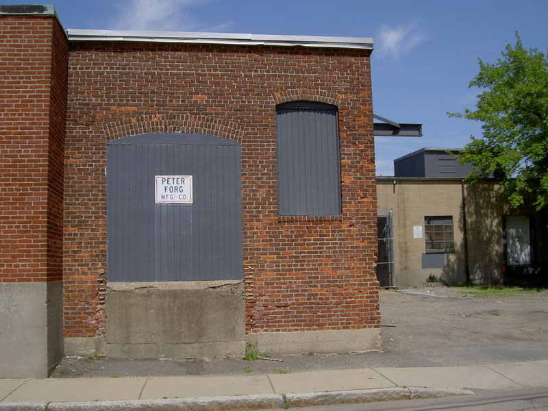
Back to Park Street, looking east. I have no idea what "special events" might take place on Forg's premises, or indeed anywhere nearby.

Looking northwest across the yard, later in the week. That fence must be pretty old, because to the right of the utility pole, there's a fragment of a tree that once grew around the wire.

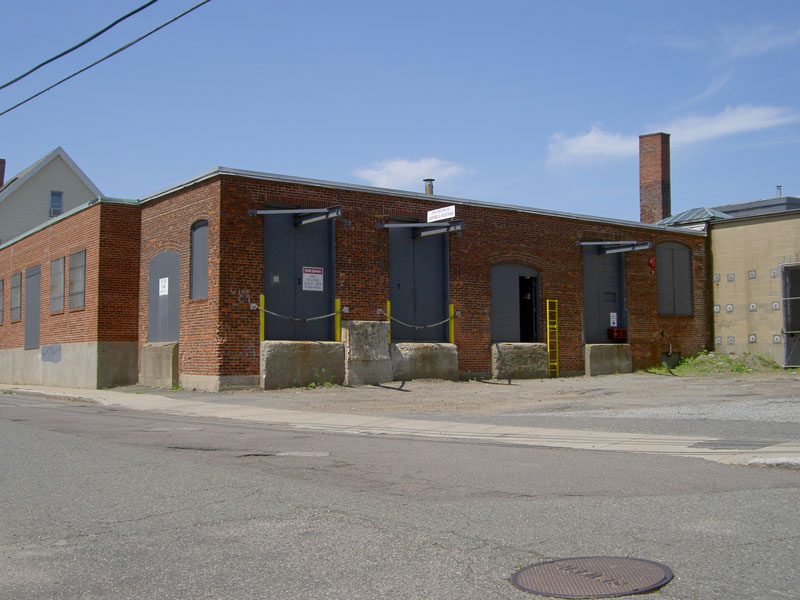
Further down Park Street, still looking east. I'd love to know how old the various pieces of this building are.

I really like these letter forms. Also, you know you're in Boston when you need elaborate directions to get to the other side of a building.

On Eliot Street, looking northwest, Forg Mfg. Co. lurks behind the houses. I wonder if the noise of punch presses and CNC mills ever keeps these people awake.
Looking north on Properzi Way. Out of frame to the right is the company's loading dock.

Accidental prettiness in one of the windows.

Further north on Properzi Way. I think it's not impossible that this door was here in 1881, perhaps loading wooden furniture frames onto horsecarts. The newer section of the building is to the right.
The loading dock. I don't know what to make of the metal things above the doors. They don't look like they ever held up an awning or anything simple and obvious like that. Maybe they were part of some cargo-handling system.

I also don't know what these things are. Structural reinforcement?

A different perspective on the building. Looking south along Properzi.
Next to Forg building, on Village Street, there's a little strip of industrial and ex-industrial buildings. This is 27 Village. At one point this building housed a forge and a machine shop. Right now it seems to house an artist's studio and a nonprofit circus.

Detail of the mural.

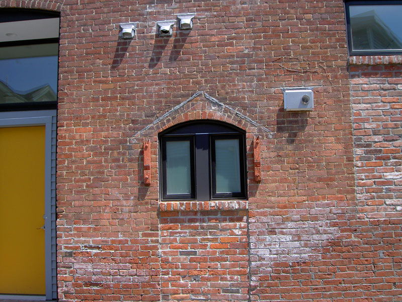
Front of 27 Village. The building seems to have seen a lot of retrofitting during its life. I'm guessing that this started out as a door and became a window. Did the red wooden things to either side hold shutters?
The building is a lot larger than its street presence would suggest. This photo is of the rear and side of the building, from across the commuter rail tracks. Notice the curved roof on the far right of the frame; that's the part that faces onto Village Street.

Next door to 27 Village. Firefly Press apparently does traditional letterpress printing, but they moved to Braintree in 2006, leaving only their name. I'm not sure who, if anyone, is in this building now. Decades ago, it was home to the Somerville Charcoal Company.

17 Village Street is occupied by the Bancroft Barrel Company. Apparently barrel companies arise spontaneously whenever two or three other factories get set up in an area. This business has been around since 1970 and is still kicking; I'm not sure what they do with the barrels; buy them, sell them, recycle them? A few days ago I saw a truck delivering a large number of blue plastic barrels to this place, so possibly some combination of the above.

Establishing brand identity does not seem to be a major priority for these guys.

L. Bornstein & Company Flooring
I can't find very much information about L. Bornstein. I don't even know if they make or simply distribute flooring. They don't seem to have a web site, very weird in these times for a business of their apparent size. A sign on their building advertises "Wholesale Flooring", but I have no idea if they make flooring or simply distribute it. What they do have is a huge, ugly, architecturally disjointed building that faces onto Dane Avenue, with a large loading dock off Washington Street. On its long edge -- the one facing the railroad track -- this structure is at least 500 feet long.The Bornstein building has been around for awhile, in some form. Early in the last century, the Metropolitan Ice Co. made and sold ice within its walls; ice and cold drinks were distributed via trucks and the rail line. (An old Sanborn map shows a space about the size of a small garage, frankly marked "beer storage".) Home freezers killed the ice companies, and the place was acquired by the Cott soft drink company. I have no idea when Bornstein bought the place, or why Cott left; they still do business in the eastern US, but don't have any holdings in Massachusetts. The building has been expanded and heavily modified in the last 50 years, with a modern loading dock having been added, and some outbuildings sold off.
We start looking east down Dane Ave. Village Street becomes Dane Avenue as it crosses Dane Street; again, classic Boston street naming. The building totally dominates the street, running at least half the length of the block. At some point, somebody must have decided to bring a little warmth to this totally dehumanized industrial box by painting it pink. That must have been decades ago, and the paint job hasn't been maintained much.

If you live on Dane Ave, this is the first thing you see when you walk out the door in the morning. This huge rectangle of nothingness is a perfect invitation to graffiti, but notice that any tagging is swiftly and crudely painted over -- this is the only time the wall gets new paint. I can see why, you wouldn't want those dirty kids to ruin something so life-enriching.

One writer seems to have tagged the wall and then sprayed over his tag, as if in ironic commentary. That was apparently good enough for the Bornstein company. This picture reveals how scabrously nasty the wall looks from close up.

A tiny sign of life on a plane of blocks. We watched this bird climb into the crack and out of sight. It seems to have a nest in the wall.

Dane Ave turns south, and the building follows the turn, maximizing usable space on the parcel of land the company bought long ago. It's weird how the pink seems to come and go when you look at this thing from different angles; some of that is poor photography on my part, but not all. Some bits of the building seem to be holding the paint better than others.

Detail of the sign, which dates from Cott's ownership of the building. I think it'd be a challenge to make these walls much uglier than they already are.

I'm guessing this was once a loading dock. Now it's a hole in the wall. I caught the worker's silhouette by pure chance. There was a fair bit of activity inside, people walking back and forth, forklifts, but I didn't feel like getting close enough to take a shot through the chain-link.

Looking south down Dane Ave, and another section of the building. This brick structure formerly housed Metropolitan Ice's freezing tanks.

Looking north.

Looking north from Washington street. The south face of the Bornstein building is set back from Washington and mostly hidden by housing, but this parking lot exposes a segment.
Closer up. Since I was in someone's front yard, I took this picture and left quickly.

Half a block east on Washington, and looking north again. The light gray building on the right was an office for the Metropolitan Ice Co; now it's the Washington Street Art Center. The large brick building across the tracks is owned by the H.D. Chasen company.

The Bornstein loading dock. The man in the Red Sox shirt had been watching me take photos for a minute or two. As I took this picture, he was walking down the ramp to inform us that we couldn't take photos there, or indeed bet here at all. We apologized and left, and I came back a few days later to get more shots of the Chasen buildings across the track. By that point I'd captured as much as I felt I needed to of L. Bornstein and his works.

H.D. Chasen
H.D Chasen is an industrial supply company that, if you believe their online catalog, seems to stock an amazing variety of stuff at their one small location. According to the "about us" page on their site, the company was started up in 1946 by the eponymous Henry Chasen. I don't know how long they've been at this location. The Sanborn maps say that there was a small parking garage and a laundry on the site in the 1930s, and then at some point a local dairy, H.P Hood and Son moved in and built new structures to house their "egg department". The map doesn't allude to any henhouses, but does show a large room labeled "Egg Testing".Hood is still around, as you'll see; it's a billion dollar corporation and its brand is very well known in New England. There's a giant Hood milk bottle in front of the Children's Museum in downtown Boston, and the Hood airship is often seen flying over sporting events. (It crashed in 2006 but is flying again.)
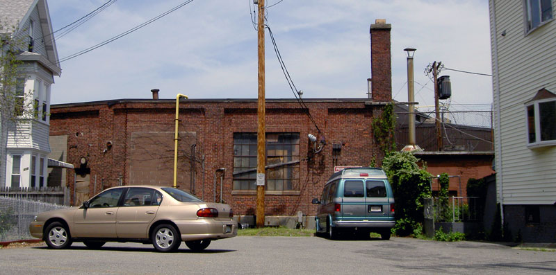
Looking south. The Chasen buildings and the parking lot seen from the intersection of Church and Lake.

Parking lot. The grim wall across the tracks is L. Bornstein's building.

Blowup of the sign. At H.D. Chasen Supply, safety, pride, and anthropomorphic tools are your guarantees of safety, pride and, um, anthropomorphic pipe wrenches.

Looking west on Lake. The north face of the building is a blank brick wall. At the end of the street is the side of the supermarket.

Panning left from the previous image, the wall ends and opens onto a small yard.

Looking west from the Washington street bridge.

I love this building. Were there eggs rolling down that metal chute decades ago?

There's Okto again, and the back of the sign seen previously.

Behind the supermarket, more graffiti, a train signal, and a Hood truck, still delivering milk.
